

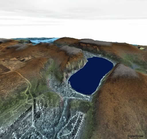
Digital Elevation Models are data files that contain the elevation of the terrain over a specified area, usually at a fixed grid interval over the surface of the earth. The intervals between each of the grid points will always be referenced to some geographical coordinate system. This is usually either latitude-longitude or UTM (Universal Transverse Mercator) coordinate systems. The closer together the grid points are located, the more detailed the information will be in the file. The details of the peaks and valleys in the terrain will be better modeled with a small grid spacing than when the grid intervals are very large. Elevations other than at the specific grid point locations are not contained in the file. As a result peak points and valley points not coincident with the grid will not be recorded in the file.
The files can be in either ASCII or binary. In order to read the files directly you must know the exact format of the entire file layout. Usually the name of the file gives the reference location to some map corner point in the file. The files usually contain only the z value (elevation value) and do not contain the actual geographical location that is associated with that point. The actual location associated with that elevation data is calculated by software reading the actual DEM file, knowing the precise location of the data value inside the DEM file. In addition, there will be some needed reference information in the header (first part) of the file. When an elevation is calculated at locations other than the actual grid points, some method of interpolation from the known grid points is used. Again, this is done in software that is external to the actual DEM file.
The DEM file also does not contain civil information such as roads or buildings. It is not a scanned image of the paper map (graphic). It is not a bitmap. The DEM does not contain elevation contours, only the specific elevation values at specific grid point locations.
Some companies chose to encrypt their DEMs, thereby prohibiting you from making your own files, converting data from other sources or allowing you access to data files that were provided from anyone other than that software vendor. SoftWright maintains an open architecture on all our data files. Details for all DEM file formats that SoftWright supports are available to any of our customers.
+ إنشاء موضوع جديد
النتائج 1 إلى 10 من 11
-
10-02-2008, 11:56 AM #1Status
- Offline

- تاريخ التسجيل
- Sep 2008
- العمر
- 36
- المشاركات
- 3,041

 عضو ملكى 100%
- معدل تقييم المستوى
- 9279

 What is a DEM (Digital Elevation Model

مهندس / اسلام ممدوح ابوضيف
مهندس مساحه تركيبات ميكانيكيه
شركه T .Q .C
-
10-02-2008, 11:57 AM #2Status
- Offline
- تاريخ التسجيل
- Sep 2008
- العمر
- 36
- المشاركات
- 3,041
عضو ملكى 100%
- معدل تقييم المستوى
- 9279
وقريبا يتم اضافه الموضوع باللغه العربيه عن نماذج الارتفاعات الرقميه فى منتدى نظم المعلومات الجغرافيه
شكرا على متابعتكم
مهندس / اسلام ممدوح ابوضيف
مهندس مساحه تركيبات ميكانيكيه
شركه T .Q .C
-
10-02-2008, 12:59 PM #3Status
- Offline
- تاريخ التسجيل
- Sep 2008
- الدولة
- Egypt/Alex/ZeZenia
- العمر
- 37
- المشاركات
- 1,127
عضو فضى 80%
- معدل تقييم المستوى
- 7247
 بجد يا سولوم 100/100 بس يا ريت تبقى تترجم الموضع علشان الغلابه اللى زينا اللى اقدر اقوله انا الصور حلوه
-
10-02-2008, 01:02 PM #4Status
- Offline
- تاريخ التسجيل
- Sep 2008
- العمر
- 36
- المشاركات
- 3,041
عضو ملكى 100%
- معدل تقييم المستوى
- 9279
ان شاء الله الموضوع هينزل بالعربى فى قسم نظم المعلومات الجغرافيه
على فكره حاولى تقرى الموضوع وتفهمى منه اى حاجه لانه مهم جدا فى شغل gis
على فكره انا مش فاهمه كله برضه انا فاهم اجزاء منه بس
وربنا يوفقك
مهندس / اسلام ممدوح ابوضيف
مهندس مساحه تركيبات ميكانيكيه
شركه T .Q .C
-
10-02-2008, 01:08 PM #5Status
- Offline
- تاريخ التسجيل
- Sep 2008
- الدولة
- Egypt/Alex/ZeZenia
- العمر
- 37
- المشاركات
- 1,127
عضو فضى 80%
- معدل تقييم المستوى
- 7247
حاضر يا اسلام وان شاء الله لما ترجع بالسلامه لو فى حاجه مش فهمنها تبقى قولهالنا
-
10-02-2008, 01:10 PM #6Status
- Offline
- تاريخ التسجيل
- Sep 2008
- العمر
- 36
- المشاركات
- 3,041
عضو ملكى 100%
- معدل تقييم المستوى
- 9279
متشكر جدا على دخولك وتشجيعك يا رنيا
وربنا يكرمكم
مهندس / اسلام ممدوح ابوضيف
مهندس مساحه تركيبات ميكانيكيه
شركه T .Q .C
-
10-02-2008, 10:28 PM #7Status
- Offline
- تاريخ التسجيل
- Sep 2008
- الدولة
- Egypt
- العمر
- 38
- المشاركات
- 1,687
مهندسه معمارية
- معدل تقييم المستوى
- 7822
That was an Excellent surveying info Mr Eslam
About this I've read That American Surveyors usually use The Term DEM which includes only elevation
data that are generally not considered as terrain surface. In most cases DEM is grid data with elevation attributes, which is suitable to use for analyses in raster GIS
But Canadian Surveyors usually use The Term DTM which includes more general information than DEM
DTM is a modeled surface structure which contains also other data of terrain as following: ridgelines, peak points etc
So if u don't Mind Mr Eslam ..Could you Explain more the difference Between the both terms later in the Arabic Topic? and Thanks any wayالتعديل الأخير تم بواسطة Mimi ; 10-02-2008 الساعة 10:32 PM

-
10-03-2008, 01:44 PM #8Status
- Offline
- تاريخ التسجيل
- Sep 2008
- العمر
- 36
- المشاركات
- 3,041
عضو ملكى 100%
- معدل تقييم المستوى
- 9279
shokran liky gidan alaa al adafa al kayma
مهندس / اسلام ممدوح ابوضيف
مهندس مساحه تركيبات ميكانيكيه
شركه T .Q .C
-
10-03-2008, 01:51 PM #9Status
- Offline
- تاريخ التسجيل
- Sep 2008
- العمر
- 36
- المشاركات
- 3,041
عضو ملكى 100%
- معدل تقييم المستوى
- 9279
but no different between DEM and DTM that mean Digital models of elevation
Arabic
In
يطلق عليها عده مسميات اولها نماذج الارتفاعات الرقميه Digital elevation models او يطلق عليها نموذج التضاريس الرقمى العددىDigital terrain Model او معلومات الارتفاعات الرقميه العدديه Digital terrain elevation Data . وغيرها من المسميات العديده ولكنها جميعا تشير الى شى واحد, تشير الى مجموعه من النقط موزعه الى سطح تضاريسى معين معلومه الاحداثيات والمنسوب بدقه , ومن خلالها يمكن بناء النماذج الرقميه التضاريسيه ثلاثيه الابعاد للمناطق المختلفه.
مهندس / اسلام ممدوح ابوضيف
مهندس مساحه تركيبات ميكانيكيه
شركه T .Q .C
-
10-03-2008, 01:53 PM #10Status
- Offline
- تاريخ التسجيل
- Sep 2008
- العمر
- 36
- المشاركات
- 3,041
عضو ملكى 100%
- معدل تقييم المستوى
- 9279
شكرا على مرورك الكريم ووفقك الله
مهندس / اسلام ممدوح ابوضيف
مهندس مساحه تركيبات ميكانيكيه
شركه T .Q .C


 رد مع اقتباس


المفضلات